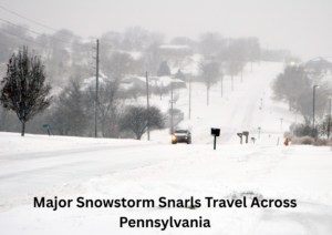


A powerful winter storm swept across the northeastern United States over the weekend, blanketing large portions of New York, New Jersey, and Connecticut with heavy snow and bringing widespread travel disruptions as conditions deteriorated rapidly.
The storm intensified on Sunday, January 25, as snow spread from southern New York northward through the day. Forecasters warned of dangerous conditions early on, with snowfall intensifying to rates of up to two inches per hour during the afternoon and evening. The National Weather Service issued winter storm warnings covering all of New York State, remaining in effect through Monday evening.
Alongside the heavy snow, bitter cold and strong winds compounded the impact. Morning wind chills dropped well below zero in several areas, while gusts reaching up to 25 miles per hour caused blowing and drifting snow, significantly reducing visibility on roads and rail corridors.
By early Monday, snowfall totals had climbed into double digits across much of the region. New York City experienced one of its heaviest snowfalls of the season, with Central Park recording just over ten inches. Several neighborhoods across the Bronx and northern Manhattan surpassed thirteen inches, while area airports measured close to ten inches, resulting in delays and cancellations.
Outside the city, even higher accumulations were reported. Parts of Orange and Rockland counties exceeded fourteen inches, while Long Island communities also saw totals well above a foot. The storm’s reach extended into neighboring states, with significant snowfall reported across Connecticut and northern New Jersey.
Public transportation systems struggled to keep pace with the storm. In Manhattan, drifting snow completely buried sections of subway entrances, forcing crews to clear access points as winds funneled snow back into pedestrian areas. The Metropolitan Transportation Authority urged residents to avoid unnecessary travel, citing hazardous conditions throughout the transit network.
Meteorologists cautioned that the impacts would not end with the storm’s departure. As the system moved east, colder air behind it was expected to generate lake-effect snow, bringing additional accumulations into early Tuesday. Snow showers are forecast to persist through the week, with several more inches possible in affected areas.
Officials continue to advise caution, reminding residents to monitor forecasts, limit travel when possible, and prepare for ongoing winter conditions as cleanup efforts continue across the region.
Don’t miss the full story-Winter Storm Brings Heavy Snow, Travel Disruptions Across Western and Southeastern Pennsylvania reveals critical impacts, safety updates, and firsthand accounts worth reading now.